
Learn More About Coal Creek

From Your Home to Coal Creek

Common household activities can be sources of pollutants, which are picked up by rain and snow and carried through storm drains into our local creeks without being treated. The communities of Superior, Louisville, and Lafayette all have storm drains that flow into Coal Creek.

Where does Coal Creek go?

Coal Creek begins south of Gross Reservoir near Highway 72 in Golden, Colorado (1). As it leaves Coal Creek Canyon it veers north to travel through Superior, Louisville, and Lafayette (2). Just east of Lafayette Coal Creek and Rock Creek join (3), continuing on as Coal Creek north through Erie. Coal Creek then joins with Boulder Creek (4). In Longmont, Coal Creek joins the St. Vrain Creek.

St. Vrain Creek, now that it has collected the water from various creeks in the watershed, exits the Boulder St. Vrain Watershed, and moves on to the South Platte River.

Assessing a water quality monitoring site along Coal Creek.

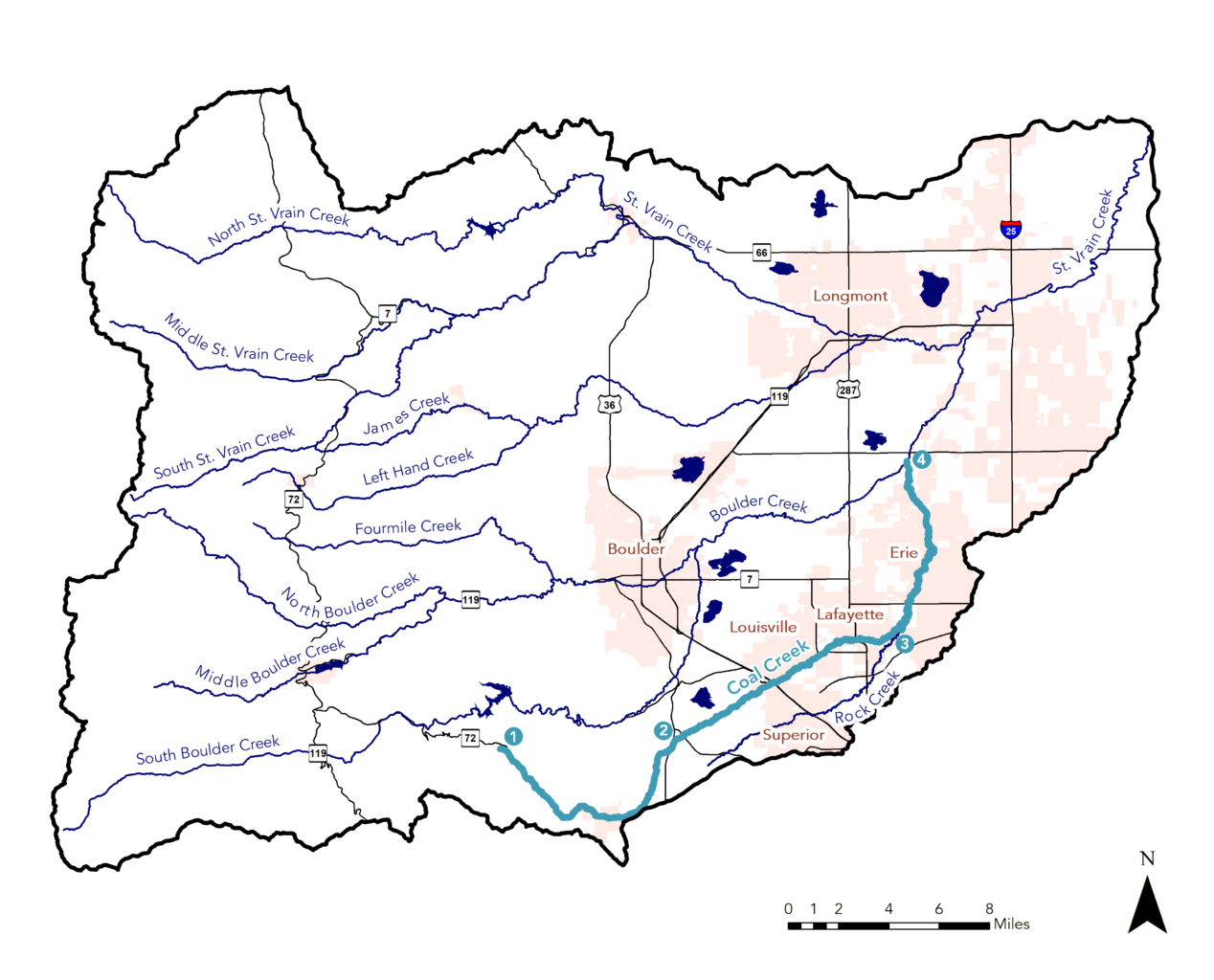
Water Quality in Coal Creek

The Boulder St. Vrain watershed generally has good water quality, but like all watersheds it is impacted by human activities. In addition to pollutants from human activities, water quality is impacted by factors like geology, land cover, and hydrology. Understanding these background factors in our watershed helps us understand potential sources of pollutants and how to address them.

Human Impact

When comparing water quality monitoring sites above and below wastewater treatment plants along Coal Creek, we can see that the inflows of treated wastewater contribute to increased levels of  total nitrogen and total phosphorus. However, long term trends show that both total nitrogen and total phosphorus levels are decreasing over time, likely in part due to the wastewater treatment plant upgrades cities are making.

Watch a video about the Lafayette Wastewater Treatment Plant and its UV waste water treatment process.

Learn about the history and treatment processes of Louisville’s Wastewater Treatment Plant.

Read an overview of the treatment process at Superior’s Wastewater Treatment Facility.

Environmental Factors

Geology is another important factor to look at when trying to understand water quality in a waterway. The geology of an area can impact water hardness and metal concentration. Our upper watershed, in the foothills and mountains, is primarily made up of older metamorphic and igneous rocks (such as granite) that do not dissolve easily in water, resulting in lower water hardness and background concentrations of some metals. The lower watershed, where Coal Creek flows, consists of younger sedimentary rocks and deposits that dissolve more easily in water, leading to increased hardness and background concentrations of some metals.

Partially burned trees along Coal Creek.

After the Marshall Fire

The Marshall Fire, which spread through Boulder County on December 30, 2021 and destroyed over 1,000 structures, burned a large portion of the Coal Creek watershed. While there are studies that look at the impacts of wildland fires on watersheds, there is not as much data looking at the impacts of urban fires on waterways. Urban fires pose different threats to waterways than wildland fires. Think about all of the human-made materials located in and around homes and businesses: building materials, vehicles, appliances, plastics, chemicals, and more. Falling ash during the fire and stormwater runoff after the fire can send contaminants from these burned items into nearby waterways.

Monitoring the Coal Creek ecosystem following the Marshall Fire
A team from CU Boulder is monitoring impacts of the Marshall Fire to the Coal Creek ecosystem. You can view the results on our public dashboard, and a summary of their findings will be shared once the study has concluded.

Things to do along Coal Creek

Ride the first Coal Creek trail segment

Ride the first trail segment! The trail from Aspen Way to Dutch Creek opened in 1990.

Coal Creek/Rock Creek Regional Trail System

The Coal Creek Regional Trail is a 14-mile of soft-surface trail that parallels Coal Creek, from South 66th Street in Superior through Louisville and Lafayette to Vista Parkway in Erie. For locals, the trail offers access to nature just steps from home while it also provides a corridor for wildlife. Starting in 1990, the Coal Creek and Rock Creek Trails project is the product of an area-wide partnership. Boulder County, the Town of Superior, the cities of Louisville and Lafayette, and the Urban Drainage and Flood Control District, all worked and will continue to work together to ensure the trail’s completion.

History provided by Boulder County

Hike towards the mountains from the Aquarius Trailhead

Find your favorite mountain peak with the Aquarius Trailhead’s “Peak Finder”.

Coal Creek/Rock Creek Regional Trail System

Head upstream from Flagg Park

Begin your walk, run, or ride from the Flagg Park Trailhead and head west for views of the mountains and our upper watershed.

Coal Creek/Rock Creek Regional Trail System

Flagg Park lies within the Boulder-Weld Coal Field and coal mining activity was very prevalent in the area during the late 1800s into the early/mid 1900s. Flagg Park is one of ten open space properties along Coal Creek owned by the City of Lafayette and Boulder County. It was purchased to preserve wildlife habitat, provide a buffer between cities, and maintain the rural character and agricultural lifestyle of the area. Developing this property into a community park began in 1979 with the process of reclamation from a landfill. Reclamation continued with drill seeding in 1980 to bring the historic shortgrass prairie species back to Flagg Park.

History provided by Boulder County

Volunteer

Volunteer to clean up a stream segment, remove invasive species and weeds, and plant native vegetation for healthy riparian areas:

Explore more!

There are many beautiful parks, trails, and open space areas to enjoy in the communities along Coal Creek! Find a park or trail near you to explore:

City of Lafayette Parks, Recreation, and Open Space

City of Louisville Parks, Recreation, and Open Space

Town of Superior Parks, Trails, and Open Space